| Home |
| About MWRA |
| Water System |
| Sewer System |
| Harbor and Bay |
| School Program |
| About MWRA |
| Doing Business with MWRA |
| Contact MWRA |
MWRA Aqueduct Trails - Frequently Asked Questions
Massachusetts Water Resources Authority
|
How does this new policy get implemented? What are the first steps in opening up these Rights-of-Ways in each town?
MWRA will work with local towns, non-profits and other groups that have expressed an interest in a particular parcel of MWRA aqueduct right-of way land that is listed as part of this policy to develop permits in accordance with this policy. Local municipal support is essential to providing access to these areas as the Towns and other interest groups must be willing partners with the Authority. MWRA is working with host communities, MAPC and other open space advocates.
Where are these areas located?
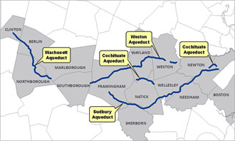
MWRA has four inactive aqueducts: the Weston, Sudbury, Cochituate and Wachusett. The aqueducts traverse 14 communities [map]
Why is a permit required?
A community, partnering with a non-profit or other entity must work out the public access details, including the types of uses allowed and the allocation of costs in advance of opening the land. Establishing rules and regulations will govern the operation of that particular space in a safe and fair manner for all. Keep in mind that each location is different and one goal of the policy is to integrate the aqueduct right’s -of-way with the surrounding open space in each community. See the Guidelines for Public Access to Commonwealth Lands under the Care and Control of MWRA for more information.
What physical improvements are required to allow public access?
In some cases, fences, gates and “no trespassing” signs currently block access to lands. MWRA and the permittee will work together to remove physical obstacles, modify fences and gates at street crossings, install trail markers and provide other proper use information prior to opening to the general public.
Will there be a contiguous path from Clinton all the way to Boston?
No, the aqueducts are not connected.
How long will this take?
Work is underway in Framingham, Southborough, Natick, and other communities. MWRA will post new information on mwra.com to keep people informed when sections of each aqueduct are open.
Who can I contact at MWRA for more information?
Sean Navin, Director of Intergovernmental Affairs - (617) 788-1112
PDF files on this website require Adobe Acrobat Reader® (free download)
Updated
February 20, 2020


