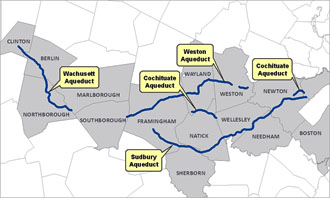
On Tuesday, May 22, 2012, Massachusetts Energy and Environmental Affairs Secretary Rick Sullivan and Massachusetts Water Resources Authority Executive Director Fred Laskey announced a new policy to make trails more accessible to the public along several MWRA aqueducts that are no longer in active service.
The new policy will provide MWRA with more control over public access activities on MWRA controlled land, while creating an opportunity for MWRA to partner with local municipalities for their enjoyment of these natural resources.
The announcement is the first step in a process. MWRA staff have begun to work with individual communities to develop agreements that detail the specifics on exact location of the trails, permitted uses, maintenance responsibilities, etc.
These agreements will preserve the Authority's primary water supply interest, while allowing host communities to officially partner with MWRA to become better stewards of MWRA land within their respective communities.
This page provides information on this new policy. Updates will be posted here. |


